Yahoo! Has Satellite Images of Manila and Davao
Jul 09 2007 Mon
11:47 pm PHT
Playing catch up with Google Maps, Yahoo! last year added satellite imagery to their Yahoo! Maps website. Naturally, being the map geek that I am, I checked out their offering last year and was disappointed to find out that they didn’t have any high-resolution satellite imagery for the Philippines, unlike Google Maps which had some back then.
So when I was geotagging my pictures of the recent Taste Asia Food Fest in Flickr (owned by Yahoo!), I was surprised to stumble upon Yahoo!’s high-resolution satellite imagery of the SM Mall of Asia. I then checked around the Philippines and concluded that they only have Metro Manila and parts of Davao City and Samal City covered.
Despite Yahoo!’s claim that their satellite data is less than two years old, both of their images for Metro Manila and Davao is no newer than 2003. Yahoo! gets their data from GeoEye while Google obtains theirs from DigitalGlobe.
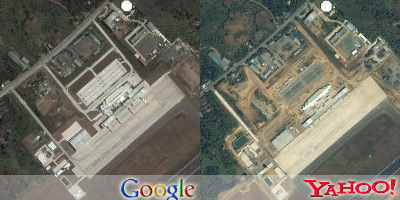
Shown above is the current satellite imagery offering of Yahoo! and Google for the new terminal of the Davao International Airport. From the images, it’s obvious that the terminal is still under construction in Yahoo! and therefore dates the image to 2003 at the latest. (The terminal opened in December 2003.)
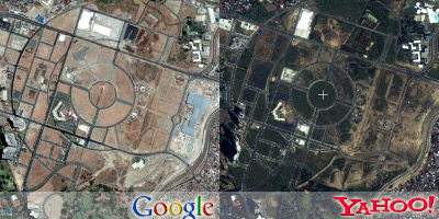
Above we have their images for Fort Bonifacio Global City. In Google, Market! Market! is still under construction (2004) while in Yahoo!, it’s nowhere to be seen!
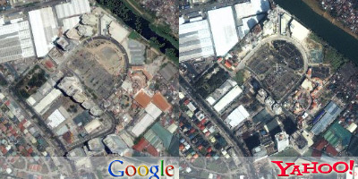
Finally, we have Eastwood City. Eastwood City is a good indicator of satellite imagery dates because a building is finished there every half year! In Yahoo!, the Cyber One Building is halfway done, the Epixtar House is still digging its foundation, and Citywalk 2 is nonexistent. This dates Yahoo!’s image to around late 2002 to early 2003. In Google, both buildings are done, the Eastwood Excelsior is being finished, and one of the three towers of One Orchard Road is done. This means that Google’s data is around September 2004.
What I find interesting is that Yahoo! seemed to adopt the exact same coordinate system as Google. This means that the image squares in both Yahoo! and Google Maps specify the exact same space on Earth. I’m sure that other people who’ve been following the mapping technologies of the big Internet players knew this but I just learned it now.

Yahoo!’s satellite imagery is definitely older than Google’s so I still prefer Google’s data right now. But one slight advantage of Yahoo! is that their high-resolution imagery of Davao contains more area than Google’s, so Dabaweños might be interested in that.
Comments
[an error occurred while processing this directive]