Maps of Dinagat Islands
Mar 19 2008 Wed
1:07 am PHT
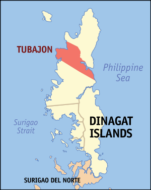
Two weekends ago, I finally got around to creating the locator maps of the municipalities of Dinagat Islands, the newest province of the Philippines that seceded from Surigao del Norte in 2006, for use in Wikipedia. Locator maps are maps that show the where a place is in a larger area. In this particular case, I am showing the location of the municipality within the province of Dinagat Islands. Shown below is a rendering of the locator map for the town of Tubajon.
I’ve been creating locator maps for Wikipedia since 2003 and it’s one thing I consider myself good at in contributing to Wikipedia. Two examples of locator maps I created before are this map of Makati and this map of Albay province. While most people can contribute to Wikipedia by writing and improving articles (like this well-written featured article about Manila’s LRT-1 that was primarily written by a high school student!), not everyone can contribute maps and illustrations. (I would like to take this moment to give a shout out to my fellow Wikipedian Mike for having completed more than 1,300 locator maps of the country’s cities and municipalities. I started the task by doing Metro Manila, Rizal, Laguna, Albay, and some of Cavite and Cebu, and he took the initiative to create the rest. Good work! 
The towns of Dinagat Islands already have locator maps before I created mine, but the old maps were created before Dinagat Islands became a separate province and so they depicted the towns as part of Surigao del Norte. So what I did was to update the maps, but this time I created them in SVG format instead of PNG so that the image is scalable without loss of resolution. For example, we can have a 1,000-pixel-width Tubajon map or a 100-pixel-width one no problem. Anyway, one good SVG software I used in the process of creating these SVG maps is Inkscape. It’s open source and therefore a favorite of Wikipedian illustrators.
So, why not join me in contributing to Wikipedia? It’s OK if you don’t know how to draw maps; we could really use some help in improving tons of Philippine-related articles. Also, photos of places in the Philippines are very much appreciated (calling all travel bloggers!).
Comments
[an error occurred while processing this directive]